Struggling Terrain for Construction of Chongqing
Chongqing, one of the most dynamic cities in southwestern China, is renowned for its challenging mountainous terrain. This “Mountain City” features a dramatic topography that has shaped its unique urban layout. Built on the hills of the Yuzhong Peninsula, which is surrounded by the Yangtze and Jialing Rivers, the city faces a constant struggle with steep slopes and rugged cliffs. Such geographical constraints have deeply influenced the city’s urban planning, particularly its pedestrian systems.
In Chongqing, the terrain demands innovative infrastructure to connect areas of differing elevations. This has led to the development of a multi-dimensional transportation system, including monorails, escalators, and pedestrian pathways, many of which have become symbols of the city’s ingenuity and resilience.
Pedestrian System in the Old City of Chongqing
Lanes and Stairs Filled in the Entire Old Town
The pedestrian system of old Chongqing is characterized by a dense network of lanes and staircases, which are an integral part of the city’s historical identity. These pathways weave through the old town, connecting narrow alleys, residential areas, and marketplaces. The stairs, often constructed from stone or concrete, serve as lifelines in neighborhoods where vehicles cannot reach. Some of the most iconic stairways include the steep Shibati (“18 Ladder Street”) and winding paths of Ciqikou, a well-preserved ancient town.
Walking through these pathways offers a glimpse into Chongqing’s past. The lanes and stairs are often lined with small shops, food vendors, and teahouses, creating a lively urban atmosphere. For locals, these pedestrian routes are not just functional but also cultural landmarks, embodying the spirit of community and the daily rhythm of life.
Conserved Pedestrian Pathway in Renewed Chongqing City
As Chongqing modernizes, efforts have been made to preserve its historical pedestrian pathways. Urban renewal projects have incorporated these traditional routes into contemporary developments, ensuring their cultural and functional relevance. For instance, the Shibati area has undergone restoration, blending old-world charm with modern infrastructure. Similarly, areas like Hongya Cave integrate pedestrian pathways into larger commercial and tourism-focused complexes.
By conserving these pathways, the city maintains its heritage while catering to the needs of residents and visitors. This thoughtful integration of old and new showcases Chongqing’s commitment to preserving its unique identity in the face of rapid urbanization.
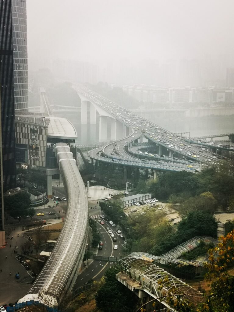
Landscaped Pedestrian System Lying on the Ridge
The Cliff Facing the Jialing River in the Yuzhong Peninsula
One of the most striking features of Chongqing’s pedestrian system is its integration with the city’s natural landscape. On the Yuzhong Peninsula, where cliffs overlook the Jialing River, pedestrian paths are designed to enhance the scenic experience. These walkways often include viewing platforms, providing breathtaking vistas of the river and the urban skyline.
For example, the Jialing Cliff Path, a popular route, winds along the edge of the cliffs, offering panoramic views of the city. This pathway exemplifies how Chongqing balances functionality and aesthetics, turning a challenging terrain into a memorable urban feature.
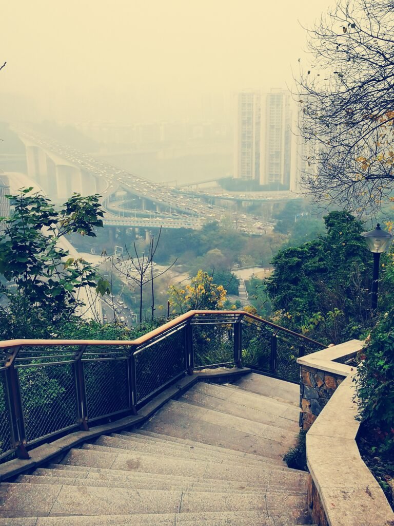
A Pedestrian Line Hanging on the Cliff
Chongqing’s pedestrian systems also include dramatic suspended walkways. These elevated paths cling to cliffs, connecting neighborhoods and providing access to otherwise inaccessible areas. One notable example is the Hongya Cave pedestrian line, which combines traditional architecture with a modern walkway suspended over the cliffside.
These walkways not only serve as practical routes for locals but also attract tourists seeking unique urban experiences. They demonstrate the city’s ability to creatively adapt its infrastructure to its terrain, enhancing accessibility while preserving its natural beauty.
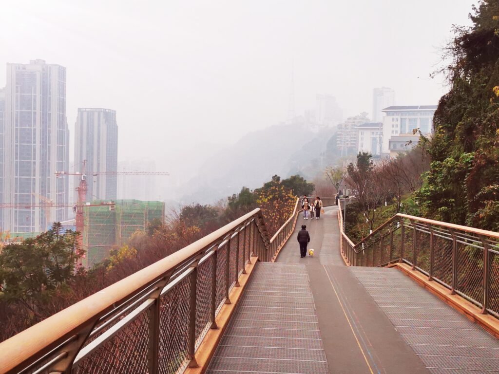
The Pedestrian Line Connecting the Peak and Foot of the Mountain
In Chongqing, pedestrian routes often connect the peaks and bases of its steep hills, creating a vertical urban network. Escalators and staircases are commonly integrated into these pathways to facilitate movement across elevations. The most famous example is the Yangtze River Cableway, which serves as both a transportation link and a tourist attraction, offering stunning aerial views of the city.
Additionally, traditional staircases, such as those in the Shibati area, provide a more immersive experience. These routes, though physically demanding, are cherished by residents and visitors alike for their historical significance and cultural charm.
Conclusions
Chongqing’s pedestrian system is a testament to the city’s ability to adapt to its challenging terrain while preserving its cultural heritage. From the dense network of lanes and stairs in the old town to the landscaped walkways on cliffs and vertical connections between elevations, these pathways reflect the city’s resilience and innovation.
For visitors, exploring Chongqing’s pedestrian routes offers a unique way to experience the city’s blend of tradition and modernity. Whether wandering through the historic Shibati area or taking in the breathtaking views from a cliffside walkway, the pedestrian system provides a window into Chongqing’s rich history and dynamic urban life.
Chongqing stands as a shining example of how urban design can harmonize with natural landscapes, creating a cityscape that is as functional as it is beautiful. Its pedestrian pathways are not just routes but stories of the city’s evolution, making Chongqing a must-visit destination for anyone interested in architecture, history, and urban exploration.

I saw a lot of website but I believe this one has something special in it in it
Thank you very much. I record some funny buildings during my domestic journey, and try to analyze them.